Showing posts with label UNESCO Sites. Show all posts

Monday, September 2, 2013

One of the New 7 Wonders of Nature

Part II.
The Puerto Princesa Subterranean River National Park, commonly referred to as the Underground River contains globally important habitat for biodiversity conservation, which includes a full mountain-to-sea ecosystem. A more thorough description and video of the cave and its faunal species dwellers are presented in this official site:  http://www.puerto-undergroundriver.com/ as well as this UNESCO site:  http://whc.unesco.org/en/list/652

This marker visibly welcomes everyone on the receiving area after the boats docking shore. Tourism officers and park's staff are all around the area helping guests and replying to their queries, even if each group has also their own tourist guides.

 These wooden planks go direct to the lake in front of the Underground River entrance. Biodiversity of endemic and native plant species populate this area of the National Park. Some trees are also labeled with the common and Scientific names for the enthusiasts.

 An old tree with reclining side branches almost cover a big portion of the lake that in a few meters meets  the sea. This lake is brackish and is mixed with seawater backflow during high tide.

 The main facade of the entrance to the Underground River. It is adorned with naturally growing epiphytes, orchids, vines, trees and many other plants and organisms.

 The main and only entrance to the UR and cave, showing a boat full of tourists already on their way out.

 Tourists are obliged to wear the orange life vests and hard hats, while boatmen are dressed in blue. One boatman manually paddles the boat and maneuvers it through the labyrinthine passageways inside the cave.

 These are the group of tourists waiting for their turn to ride the boats to the cave. There is also a systematic queue for the boats to beautifully implement traffic and safety measures.

 Different forms of the rock structures can be deciphered from the formations inside the cave walls and ceilings. The stalactites are the most spectacular, but there are no prominent stalagmites as drippings fall mostly on water.
These structures are very prominent and beautiful, made specifically by the minerals left when water flows on them. These are still actively growing because water still continue to drip along those lines carrying the cations to be deposited here that will eventually lengthen and enlarge them.

 Boats going in at the right and go out at the left and the traffic continues in a few minute intervals making a queue like an organized parade.

 There is a fluted roof pattern in some cave roofs. The presence of 20 million year old Serenia fossil embedded in the walls of the cave justifies its declaration as one of the New 7 Wonders of Nature.

Above figures are bats making these cave their home. One side branch dome of the cave is called Bat cave because a lot of bats converge in that area. The smell of guano (a very good fertilizer) or bat excretions is very prominent near the Bat Cave. Several chambers are seen in the expanse of the UR tour.

 Can you see the big bird resting on the wall? What about the dog that seems to be communicating with the bird. The focused light is from the flashlight provided to each boat and held by one of the passengers in front of the boatman. He points to the side directed by the boatman.

 The entrance viewed from inside on our way out. It takes at least 45 minutes to navigate the entire cave.

Those rock nodules at the foot of the rock are caused by water decomposing minerals found in the rocks.

Those horizontal lines at the foot of the rocks are caused by levels of water because of the changing tides.

This is already the close-up of the UR facade showing the wall with criss-crossing boulders.


Thursday, August 29, 2013

One of the New 7 Wonders of Nature

Our long planned trip to El Nido, Palawan was aborted due to low registrants for that group tour. The plane ticket in going there is via Puerto Princesa, and land trip to El Nido from there. We already had plane tickets so we decided to use them at least only to Puerto Princesa instead of continuing to El Nido. One month before the designated date we registered online for the Underground River, because access to this UNESCO Heritage Site is now limited to 900 persons per day unlike the 1,500 before. I have actually visited it more than 10 years ago, many years before it was voted as one of the New 7 Wonders of Nature. It is high time that i refresh the memories, or maybe compare the differences accruing from the so-called "development".

There are 12 persons in our van plus a tour guide. It took about 1.5 hours from Puerto Princesa City to Sabang town, where a boat takes the tourists for 30 min to the front of the Underground River. A boat rides only 4-6 persons including the boatman. Then a short walk brings us to the other side of the Cave's entrance. Here, another boat takes us directly inside the cave, this is manually paddled by a boatman who at the same time acts as the tourist guide. He sits at the back of the boat and while paddling tells us information about the Cave and the Underground River. We are very fortunate for having someone who delivers his messages with amusing, sometimes really hilarious punchlines that make all of us laughing all the way!

Part I. Way to the Underground River

The Van that took us from Puerto Princesa City to Sabang town, jump-off point to the Underground River. The man on the left is our tourist guide. There are 4 mini groups in our van. 

This is the makeshift pier in Sabang town, where tourists board on the boats. That mountain is a tropical virgin forest where no patch of agricultural activity can be viewed from the plane or from the way we were.

The above view of the mountains and the sea might already entice you to stay in this area to explore for more happenings and experiences. There is a zipline here, a mangrove exploration tour, a monkey trail hike, among others.

 The view at our right side from the boat. Our guide said the range looks like a reclining giant.

 Another peak on that range, these mountains are limestone in character, that eventually resulted in having the Underground River and cave. It is not yet very well explored but many caves are in those mountains.

 The shoreline cliffs viewed from the boat. The occlusions or deep contours at the rock facade shows the level of sea water long ago. It was now way up the present sea level because the rocks are pushed up due to the tectonic plates merging in these parts, making big movements.

Boulders fall now and then due to constant movement of the crust and constant weathering

This big boulder originally has an arch but now blown away

 This long rock wall lines the way to the shore where the boats dock going to the UR

 Another view of the rock wall


Big old trees of >1 meter diameter can be seen on the area to the UR. Monkeys also roam around like that one above right. We saw five of them on the ground and some tourists even pose with them for photos. Another group with monkey kids are on top of the concrete structure that serves as the toilet and comfort room. They seem to be gentle and are used to be with a lot of people. 

Part II follows tomorrow.


Wednesday, February 9, 2011

An Early Vacation in 2011 Part 3

After our Borobudur experience and on the way to the airport to send off our companion returning home, we visited another temple on top of a hill, Candi Ijo (Temple Ijo). We had to walk maybe 200m of uphill unpaved road, leaving our car below.  It is a very strategic temple to clearly see the lowlands, but we had only a few minutes to take photos.

 Candi Ijo at present is composed of a big temple with 3 smaller ones. A big area is still not yet reconstructed, but the piles of stones are seen below right.
   
At the left is the linga at the center of the biggest temple, many of these are also seen in some temples in Angkor Wat in Siem Reap, Cambodia. Its top directly points to the rooftop with small hole for water to seep through. Water droplets are collected at the base of the linga and believed to be medicinal or even magical. Top right shows the ruins of Candi Ijo waiting for reconstruction.
After sending our companion to the airport, four of us still continued our Indonesia escapade by taking a train from Yogyakarta to Solo, Surakarta. It is a place often suggested in travel sites as an old town with beautiful cultural traditions. For us it really is an awesome experience! After checking two hostels which were full, our taxi driver brought us to a homestay, located along narrow, circuitious residential areas. It was a bit difficult to traverse these alleys, as there are many motorcycles going around, motorcycles being their primary mode of transport. Chakra II Homestay was our hostel for 2 nights in Solo. It is in a big compound with many rooms, and a swimming pool. Serendipitously, it houses the Gamelan Orchestra that practices there every night. A gamelan is a musical ensemble from Indonesia, typically from the islands of Bali or Java, featuring a variety of instruments (http://en.wikipedia.org/wiki/Gamelan). We are free to watch them practice and take photos of the traditional instruments.

Top left: Chakra II Homestay Gamelan Orchestra playing on the floor; Top right: one of the side lobbies at Homestay where we take our free breakfast.                                                        


Top left: an elaborately carved walls for another set of Gamelan instruments. Top right: Wayang Kulit puppet at the Museum in Solo.
Top left: Batik making in one of the batik shops; Top right: image of Visnu in a side street

Becak (pronounced betsak) - unmotorized tricycle and manually pedalled by the operator is a common local mode of transport. Photos 8 & 9 are not becak but #8 is a mobile delicacy store, while #9 is a carriage drawn by a horse. All of the mentioned modes of transport are always very colorful in Yogyakarta and Surakarta, most especially in Solo.

Colored doors and windows of Solo. It is a cultural tradition in Solo to have brightly colored gates, windows, doors, as well as the becak (pedalled unmotorized tricycles).  At bottom right is a mosque door.

Our trip back home entailed an hour by train from Solo, Surakarta to Yogyakarta; followed by another hour of Asia Airlines domestic plane to Jakarta, and lastly, 4 hours via Cebu Pacific Airlines to Manila. We lost an hour in crossing the dateline, but we gained a lot from the wonderful sights and experiences.

Postscript: For a more detailed article of our trip to Indonesia, please visit http://www.lagalog.com/

Monday, February 7, 2011

An Early Vacation Part 2

Our second night in Jogjakarta (pronounced Dyogdyakarta there but Yogyakarta for non-Indonesians) was spent at the Manohara Hotel, only five walking minutes to the Borobudur Temple. We arrived there at about 4 pm with grey skies and rains, but it did not deter us to approach the foot of the temple which closes at 5 pm. Good thing that we are prepared with hats, umbrellas, raincoats, dry bags and camera covers.

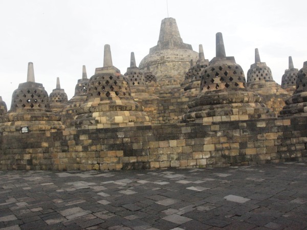
At 4:30am the following morning we started our walk to the temple for the sunrise shots. Manohara Hotel provides guides and flashlights for the resident tourists. The stairs are a bit steep, but there are stainless rails added lately to avoid accidents. There are nine levels, but the 2 top levels are still closed due to the destruction by the recent eruption of Mt Merapi. The temple really depicted the visualized Path to Enlightenment. The first levels show wall-stone carvings of the mundane things, including human vanities and pursuit of worldly happiness. As the level rises the carved pictures lessen, with the topmost and biggest stupa already devoid of any human or animal depictions. This show the disappearance of worldly concerns as the consciousness approaches enlightenment. Literatures say that the biggest and topmost stupa is open and contains nothing both inside and out. Several stupas in the lower levels contain the bust of the Buddha.

Above and Below: The Manohara Hotel complex


The approach to the Temple of Borobudur before sunrise in a really foggy cold morning


      I am sorry i still don't know how to merge photos, the topmost protruding stupa is the topmost center of the Borobudur Temple. Besides, my wide angle is not as wide to capture it in just a click!


 The Path to Enlightenment is very steep, and the symbol to get that is steep too! At the right is the moon on top of the central dome

 
Top left: Mt Sumbing at the background, the highest volcano around Borobudur. Top right: the side walls along the pathways upward the temple.


Those stupas have Buddha's bust inside, and at the top right is an open stupa showing the Buddha


The central dome or Stupa is already devoid of carvings, signifying the clean consciousness after undergoing the travails of life and diligent cleansing and good deeds. At the right shows details of walls at the mid levels of the temple, of people in meditation pose, to be one with the Divine.

Left: the walk at the mid-level of the temple. Right: the gargoyle serves as water spouts

 The wide angle view taken from the grounds of Manohara Hotel.


Postscript:
For a more detailed description of the places and events we saw in Indonesia in this trip, i would like to recommend you see this link from my journalist friend. He writes and photographs better and even put the cost and prices for hotels, entrance fees, and transport, hahaha. http://www.lagalog.com

Related Posts with Thumbnails