Monday, March 27, 2017

The Cozy Coast or Kusikos de EveRim!

The brackishwater in this part of La Union is a very beautiful and rich natural resource. The people there call this a river, but i think it is a large pool of water developed during the rainy days with very high tides. I did not see the actual flowing water from a river coming from a continuous upstream source. The good thing about it is the size and shapes of the pools. Moreover, there are big islets with grown colonizing vegetation. There are also small islets good for picnics and small games. There are nooks along the waters, and there are surprises as you boat along or there are surprises at the other side of the islands. We were not even able to explore the full expanse of the waters beyond all the islets.

A friend has a property near the waters, and she plans to make a bigger hut, bring in kayaks and build bamboo rafts not only for friends but also let visitors rent them for a small fee. Her property caretakers of husband and wife will be very busy these next few summer months, when people seem to frequent bodies of waters for fun, bonding with friends and adventure. And we did clamming too, gathering oysters, shells and the famous kusikos! It was really a lot of fun. We also had fun using the word as a verb or adjective and more, e.g. we will come back for more kusikosing! Or expression of awe, e.g. what a kusikos! Isn't it lovely. Come and join us.

And the most spectacular view visitors will see here is the sunset. I have been to many beaches and i can vouch for the most beautiful sunset scenes here. My photos might not be good evidences of my claims, but i assure you they are much better to see in person.


A lot of birds can be heard and seen while we are on our boat raft-hut. We spotted a lot of egrets, some blue kingfishers, and many more we don't know the names. Some are just solitary walking on some shores to look for their food, like the white egret above. 


 One enterprizing farmer brough a few cows there, made his hut at the center and enclosed his abode with fences of thorny branches to discourage entrants and curious folks. The scarecrow serves as direct message to intruders.

the thorny branches around the enclosed property with cows

The hut at the middle of the enclosure, and silhouetted in this picture is a bit far from us, so we cannot get its bigger view in nice details. It was made of grasses, both walls and roofs, to be cool even at midday. 
 
The factory at the horizon is already at the mainland. I guess this yellow boat is owned by the owner of the hut with thorny fences.. 

The sand might be beautiful with those patterns, a semblance of what we see in the desserts. But i tell you, it is difficult to walk barefoot in sands like this. My weight maybe is too much for my feet to be agile on it. 

After traversing the patterned sands for a few minutes, we reached the real beach, it is now the West Philippine Sea, also a vast ocean. We reached it just in time for the sunset. Oh My God, i forgot my big camera with CPL at our boat raft. I only have my small Olympus OMD-EM10.  Now, be the judge. Tell me what you think of this sunset scenes. 

I stayed here longer than my 3 companions, as the lacey, lovely waters breaking from the waves and hurriedly approaching the shore are very beautiful. I took lots of shots, but eventually just stayed there to imbibe the serenity and stillness of the scenes. 

 That is my friend also being mesmerized by the almost holiness of these whole drama unfolding before us. Can you blame me for already missing this and wanting already to come back?

 I was lost for words to describe this scenes and the feelings of awe while imbibing everything all at the same time. I just thank God for the experience, the opportunity and the privilege of having friends who make things happen.

 The drama is at the denouement, and we are about to go home.


Above is the raft my friend hurriedly commissioned people to make, in time for our visit. Clutching our shell harvest (oysters, kusikos, other shells, bivalves and univalves), we went home satiated, contented and happy. We are ready for a good night sleep!


Tuesday, March 21, 2017

Exhilarating Experience

I did not go to the office last Friday, 17th March. I left at 3:00am to take the 4:00am bus for a 6.5 hours ride to the north of Manila. I will be joined by my friend from Baguio City and we will be staying with my friend in La Union. She will take us to a waterfall near her place. Serendipity came in as the tourism officer will be bringing some people who won the raffle in their Agri-fair Exhibit. It is one of their promotions for people to visit one of their waterfalls in their town, in fact there are a few more waterfalls there. So we left my friend's car at the Santol Poblacion for the hired vehicle that brought us to the Simminublan Falls. The jeepney was full and a few guys together with my friend took the topload, or on the jeepney rooftop.

As far as this lifetime is going, i can say that this ride and that route to the Simminublan Falls, Santol, La Union is the most exhilarating and scary one! The road is paved to the top of the mountain but rough downwards to the other side where the waterfall is. But the slope, OMG, is definitely only a little less than 90 degrees. It is circuitous and both sides of the road are deep steep ravines, that if we fell there nothing will stop us from reaching the bottom, not even a big boulder. I tell you, it is more than a roller coaster ride. All of us held tightly to the jeepney roof handles! Sometimes, someone gasped, or screeched, involuntary controlled screams that got out from their mouths.

I was able to get a few hurried shots, although they did not show the real dimensionality of the area. They still appeared flat, not that scary as in the real experience. (please move over your mouse for a bigger and clearer picture)

 This is taken while going up to the top of the mountain, afterwhich, it swiftly went down on a rugged unpaved road. I can just think of what it is during the rainy season, maybe more difficult and more scary! The tourism officer said only single motorbikes can traverse this road during the rainy season.

above shows the not so steep part of the road to the top

 The barangay road is only as wide as a jeepney, it is good that nothing comes here but single
motorcycles. Or else the other vehicle will take reverse until the point it started, and that is at the bottom of the mountain. There are portions of the road where both sides are very steep ravines, with nothing to bar you from falling, not even a big tree!

 another view of the other side of the mountain

another expanse at the side of the road

I felt that everybody almost held their breaths most of the time. And maybe a few said some secret self prayer of thanks to God when we at last reach the bottom of the road, a dead end. And from there, a few more steps brought us to big boulders, which kept our destination, the Simminublan Falls.

All of us have picnic baskets, some even have a radio, and of course a large tarpaulin for shade. Most of them swam in the big basin-like catchment of the falls. All the men tried jumping on the water from the rock cliff.

 I did not join them, as my other purpose is to shoot some wildflowers and butterflies. There are also a lot of dragonflies and damselflies, so they also took my fancy.
 
This is the total expanse of the waterfalls, in cascades. They said it is about 30ft in height. The water now is not as big as during the rainy season. It would be lovely then, but i doubt if i can be brave enough to take that single motorbike on slippery steep road during the rainy season.


 the 2nd cascade from the bottom

2nd cascade even enlarged

My friend is the only lady who took the plunge from the cliff. She even wanted to start from the topmost rock, but there are no holds to get there. We were all at the sides, taking her picture. 

the vegetation around the falls

That is a summary of that experience. My more extreme-adventurer friend still wants to visit more of the falls that need more hiking hours. However, i think i need to ask for more details of the road going there before i decide to join her again. 

Below is my friend's video of the road going there and back. 


Monday, March 13, 2017

Malimatoc Beach with Character!

Our town is a peninsula, protruding from the province of Batangas, Philippines. At the west side where the sun sets is a marine sanctuary which has lots of internationally known scuba diving sites. It follows that most of the resorts are found there. Our side of the town is where the sun rises, and we get spectacular sunrises. However, the disadvantage of living in an area like this all your life, is that we almost take for granted its beauty. Maybe tourists or visitors take lots of photos here, but residents like us normally don't.  I just have a few photos because i often pass by here, as the jeepneys start from this area. Our road to town is basically along the shore, but houses now block the shore views. It is not a good type of development, but that is our reality!

This is a bay or a big cove, and the Batangas International Port is at the other side of the bay, where the sun rises. I am just giving you a few compilation of this area, to show our bay's character. Sometimes it is serenely inviting, but most times it is not. An area between those islands at the east directly goes to the Pacific Ocean, giving us strong currents too. Because the west side is famous, this side of the town is not sought after by tourists. As a resident, i think i love it better that way. .

a  serene sunrise

lacey shoreline during serene sunrise

A very calm day and very calm waters. This view is also the scene at my header.

Stormy days bring the ships to our shores to hide. Those are fast craft passenger ships. 

A rocky beach give some residents to gather live shells for food


 Those fortress-like big structures were there only for maybe 3 yrs, a flour and cement factory. Brown waters are here when seas are rough, and the sounds of bumping rocks underneath the waves are sometimes scary. 

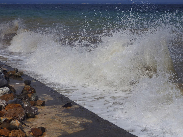
 Waves look like this during slightly rough seas at high tides. 

I like looking at those waves when they hit the cement breakwaters

 That island at the horizon is Tingloy, another town, not anymore part of our own. At the farther right of that big island are some small islets that are often visited by tourists in Anilao, Mabini, Batangas. Some resorts include lunch in those beaches as part of their itineraries. At the back shore of that big island is where the Magsasa Beach is located, a beach side very famous for local tourists these days. It is known to have finely white sands so attractive because of the nearness to Manila at 4 min to 1 hour from Anilao port. Further, Anilao to Batangas Grand Terminal is about 1 hr, and to Manila is 2 hours through the newly constructed CALABARZON Expressway. 

Monday, March 6, 2017

A Respite from the Madding Crowd Below

We were out of town for a week for an official trip, to evaluate some research projects for Mindanao. It is the largest island in the Philippines and composed also of many geographical regions. The project leaders in 6 regions were there together with their assistants. A few of us from our office, the funding agency, left our houses as early as 5:00am last Monday, spent the whole day en route to the site. From their airport it took us 5 hours in circuitous and undulating roads to reach the place.

The station is at a mid-level elevation, with comparatively lower temperatures than us here in the lowlands. It was a very pleasant  environment on rolling planes with mountain ranges surrounding it. All of us feel like we are looking at the expanse of the hacienda of old, during the Spanish colonial period centuries ago. A cowboy complete with gears on a horse is very fitting in  its atmosphere. Moreover, the food and native delicacies are super yummy, that all of us ate more than what our bodies need.

And most of all, even with very little time left for us to wander, i got at least some few photos. I hope you will agree with me! Lastly, this is in the province of Bukidnon, with their airport called Laguindingan Airport.

The Guest House, our hostel for four days, where we also had some bonding moments. 

 To the East of the Guest House are expanse of farms bordered by a series of mountain ranges. Those mountains are usually cloud covered in early mornings and at dusk.


 Above is still at the east after the sunset. Cloudy skies did not let me take sunset shots.  

 If only we had more time, it would be nice to spend some hours on that nipa hut, with the cool fresh wind absent in the big city. There are also fresh water fish in the above pond. 

Mt Kitanglad at the West is still forested, nurturing a lot of biodiversity. The vegetation is contrary to the almost completely barren mountains at the east side. 

a lovely painting on water

another water painting

Can you see the two dating ducks, wading on water in a very isolated corner! If the waters are teeming with life, the trees are also filled with birds, and their tweets provide a very different type of music to the city dwellers like us. 

Impatiens balsamina scattered at the roadside growing as weeds, 
but very beautiful against a green background. 


 the salad reflects the beauty of the surroundings, these are also products from their farm

 another delicious salad, pomelo salad

And who will not appreciate a tree like above! For  days I had been waiting for the sunset against this tree, but clouds didn't allow me to. Nevertheless, it is still a lovely view. 


Related Posts with Thumbnails